চিত্ৰ:Bhutan CIA WFB 2010 map.png
ইয়াতকৈ ডাঙৰকৈ দেখুৱাব নোৱাৰি ।
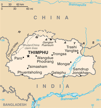
Bhutan_CIA_WFB_2010_map.png (326 × 350 পিক্সেল, ফাইলৰ মাত্ৰা: 16 KB, MIME প্ৰকাৰ: image/png)
| এই ফাইলটো ৱিকিমিডিয়া কমন্সৰ পৰা আমদানি কৰা হৈছে। ফাইল বিৱৰণ পৃষ্ঠাৰ সবিশেষ তথ্য তলত উল্লেখ কৰা হ’ল ।
|

|
This map image could be re-created using vector graphics as an SVG file. This has several advantages; see Commons:Media for cleanup for more information. If an SVG form of this image is available, please upload it and afterwards replace this template with
{{vector version available|new image name}}.
It is recommended to name the SVG file “Bhutan CIA WFB 2010 map.svg”—then the template Vector version available (or Vva) does not need the new image name parameter. |
সাৰাংশ
| বিৱৰণ | Bhutan map from CIA World Factbook (since June 24, 2010) |
| তাৰিখ | |
| উৎস |
CIA World Factbook, converted from original GIF format |
| লেখক | United States Central Intelligence Agency |
| অন্যান্য সংস্কৰণ |
|
অনুজ্ঞাপত্ৰ
This image is in the public domain because it contains materials that originally came from the United States Central Intelligence Agency's World Factbook.
|
 |
ফাইলৰ ইতিবৃত্ত
ফাইলৰ আগৰ অৱস্থা চাবলৈ সেই তাৰিখ/সময়ত ক্লিক কৰক।
| তাৰিখ/সময় | ক্ষুদ্ৰ প্ৰতিকৃতি | আকাৰ | সদস্য | মন্তব্য | |
|---|---|---|---|---|---|
| বৰ্তমান | 19:40, 6 July 2017 | | 326 × 350 (16 KB) | Ras67 | cropped, opt. |
| 11:56, 12 May 2015 |  | 330 × 354 (52 KB) | Evolt | Updated to version as of April 24, 2015 | |
| 12:17, 22 August 2011 |  | 330 × 354 (18 KB) | Zyxw | =={{int:filedesc}}== {{Information | Description = Bhutan map from CIA World Factbook ([http://web.archive.org/web/20100704230847/https://www.cia.gov/library/publications/the-world-factbook/geos/bt.html since June 24, 2010]) | Source = CIA World Factbook, |
ফাইল ব্যৱহাৰ
তলত দিয়া পৃষ্ঠাটোৱে এই ফাইলটো ব্যৱহাৰ কৰে:
ফাইলৰ গোলকীয় ব্যৱহাৰ
তলত দিয়া আন ৱিকিসমূহে এই ফাইলটো ব্যৱহাৰ কৰে:
- ace.wikipedia.org-ৰ ব্যৱহাৰ
- af.wikipedia.org-ৰ ব্যৱহাৰ
- als.wikipedia.org-ৰ ব্যৱহাৰ
- ar.wikipedia.org-ৰ ব্যৱহাৰ
- bcl.wikipedia.org-ৰ ব্যৱহাৰ
- bh.wikipedia.org-ৰ ব্যৱহাৰ
- bjn.wikipedia.org-ৰ ব্যৱহাৰ
- bn.wikipedia.org-ৰ ব্যৱহাৰ
- ca.wikipedia.org-ৰ ব্যৱহাৰ
- cy.wikipedia.org-ৰ ব্যৱহাৰ
- da.wikipedia.org-ৰ ব্যৱহাৰ
- de.wikipedia.org-ৰ ব্যৱহাৰ
- de.wiktionary.org-ৰ ব্যৱহাৰ
- dv.wikipedia.org-ৰ ব্যৱহাৰ
- dz.wikipedia.org-ৰ ব্যৱহাৰ
- en.wikipedia.org-ৰ ব্যৱহাৰ
- en.wiktionary.org-ৰ ব্যৱহাৰ
- eo.wikipedia.org-ৰ ব্যৱহাৰ
- es.wikipedia.org-ৰ ব্যৱহাৰ
- eu.wikipedia.org-ৰ ব্যৱহাৰ
- fa.wikipedia.org-ৰ ব্যৱহাৰ
- fi.wikipedia.org-ৰ ব্যৱহাৰ
এই ফাইলটোৰ অধিক গোলকীয় ব্যৱহাৰ চাওক।