চিত্ৰ:Cooch Behar from 1931 Imperial Gazetteer.jpg
মূল ফাইল (780 × 744 পিক্সেল, ফাইলৰ মাত্ৰা: 527 KB, MIME প্ৰকাৰ: image/jpeg)
| এই ফাইলটো ৱিকিমিডিয়া কমন্সৰ পৰা আমদানি কৰা হৈছে। ফাইল বিৱৰণ পৃষ্ঠাৰ সবিশেষ তথ্য তলত উল্লেখ কৰা হ’ল ।
|
সাৰাংশ
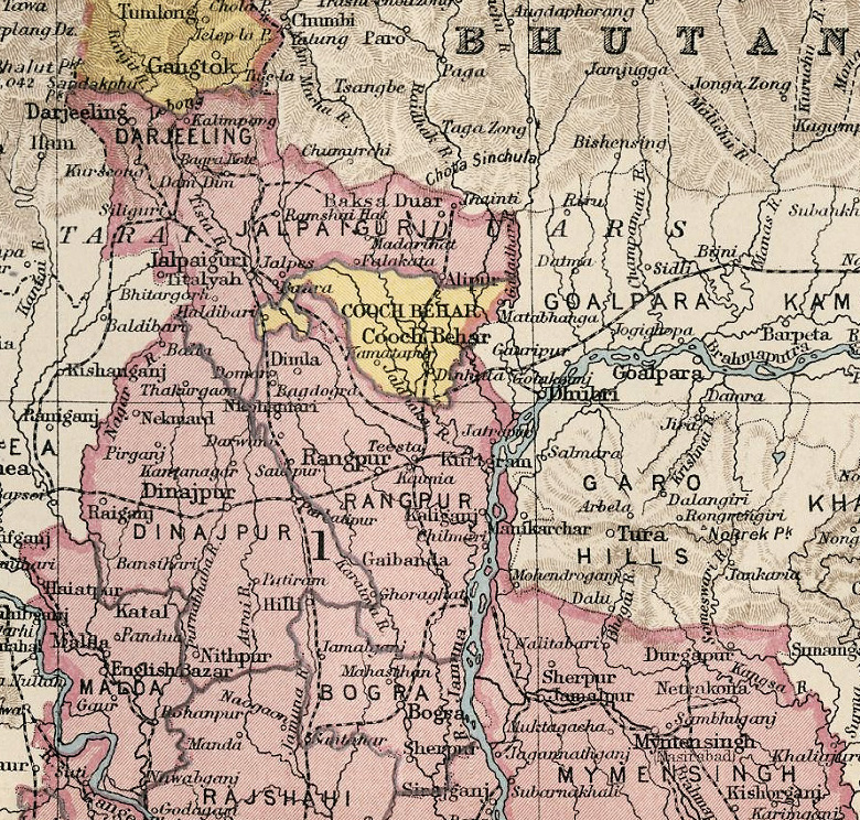
| বিৱৰণ | Map of Cooch Behar and surrounding regions |
| তাৰিখ | |
| উৎস | Imperial gazetteer of India, Atlas. |
| লেখক | Meyer, William Stevenson, Sir, 1860-1922, et al. |
অনুজ্ঞাপত্ৰ
|
This work is in the public domain in its country of origin and other countries and areas where the copyright term is the author's life plus 70 years or fewer.
| |
| This file has been identified as being free of known restrictions under copyright law, including all related and neighboring rights. | |
ফাইলৰ ইতিবৃত্ত
ফাইলৰ আগৰ অৱস্থা চাবলৈ সেই তাৰিখ/সময়ত ক্লিক কৰক।
| তাৰিখ/সময় | ক্ষুদ্ৰ প্ৰতিকৃতি | আকাৰ | সদস্য | মন্তব্য | |
|---|---|---|---|---|---|
| বৰ্তমান | 18:12, 8 April 2009 | | 780 × 744 (527 KB) | Aymatth2 | {{Information |Description=Map of Cooch Behar and surrounding regions |Source= Imperial gazetteer of India, Atlas. |Date=1931 |Author=Meyer, William Stevenson, Sir, 1860-1922, et al. |Permission= |other_versions= }} |
ফাইল ব্যৱহাৰ
তলত দিয়া পৃষ্ঠাটোৱে এই ফাইলটো ব্যৱহাৰ কৰে:
ফাইলৰ গোলকীয় ব্যৱহাৰ
তলত দিয়া আন ৱিকিসমূহে এই ফাইলটো ব্যৱহাৰ কৰে:
- bn.wikipedia.org-ৰ ব্যৱহাৰ
- ca.wikipedia.org-ৰ ব্যৱহাৰ
- de.wikipedia.org-ৰ ব্যৱহাৰ
- el.wikipedia.org-ৰ ব্যৱহাৰ
- en.wikipedia.org-ৰ ব্যৱহাৰ
- fr.wikipedia.org-ৰ ব্যৱহাৰ
- it.wikipedia.org-ৰ ব্যৱহাৰ
- ja.wikipedia.org-ৰ ব্যৱহাৰ
- pnb.wikipedia.org-ৰ ব্যৱহাৰ
- ru.wikipedia.org-ৰ ব্যৱহাৰ
- ta.wikipedia.org-ৰ ব্যৱহাৰ
- te.wikipedia.org-ৰ ব্যৱহাৰ
- ur.wikipedia.org-ৰ ব্যৱহাৰ
- vi.wikipedia.org-ৰ ব্যৱহাৰ
- zh.wikipedia.org-ৰ ব্যৱহাৰ