চিত্ৰ:Tectonic plate boundaries.png
ইয়াতকৈ ডাঙৰকৈ দেখুৱাব নোৱাৰি ।
Tectonic_plate_boundaries.png (775 × 429 পিক্সেল, ফাইলৰ মাত্ৰা: 83 KB, MIME প্ৰকাৰ: image/png)
| এই ফাইলটো ৱিকিমিডিয়া কমন্সৰ পৰা আমদানি কৰা হৈছে। ফাইল বিৱৰণ পৃষ্ঠাৰ সবিশেষ তথ্য তলত উল্লেখ কৰা হ’ল ।
|
সাৰাংশ
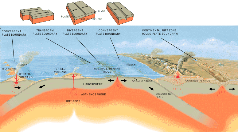
| বিৱৰণ | A cross section illustrating the main types of plate boundaries. |
| তাৰিখ | |
| উৎস | [1] |
| লেখক | Jose F. Vigil. USGS |
| অন্যান্য সংস্কৰণ |
Slovenian translation, Spanish version
[]
|


অনুজ্ঞাপত্ৰ
This image is in the public domain in the United States because it only contains materials that originally came from the United States Geological Survey, an agency of the United States Department of the Interior. For more information, see the official USGS copyright policy.
|
ফাইলৰ ইতিবৃত্ত
ফাইলৰ আগৰ অৱস্থা চাবলৈ সেই তাৰিখ/সময়ত ক্লিক কৰক।
| তাৰিখ/সময় | ক্ষুদ্ৰ প্ৰতিকৃতি | আকাৰ | সদস্য | মন্তব্য | |
|---|---|---|---|---|---|
| বৰ্তমান | 15:40, 26 December 2005 | | 775 × 429 (83 KB) | Merikanto~commonswiki | Illustration by Jose F. Vigil. USGS. [http://pubs.usgs.gov/gip/earthq1/plate.html] {{PD-USGov-Interior-USGS}} |
ফাইল ব্যৱহাৰ
তলত দিয়া পৃষ্ঠাটোৱে এই ফাইলটো ব্যৱহাৰ কৰে:
ফাইলৰ গোলকীয় ব্যৱহাৰ
তলত দিয়া আন ৱিকিসমূহে এই ফাইলটো ব্যৱহাৰ কৰে:
- ar.wikipedia.org-ৰ ব্যৱহাৰ
- az.wikipedia.org-ৰ ব্যৱহাৰ
- ba.wikipedia.org-ৰ ব্যৱহাৰ
- bg.wikipedia.org-ৰ ব্যৱহাৰ
- bs.wikipedia.org-ৰ ব্যৱহাৰ
- da.wikipedia.org-ৰ ব্যৱহাৰ
- de.wikipedia.org-ৰ ব্যৱহাৰ
- en.wikipedia.org-ৰ ব্যৱহাৰ
- en.wikibooks.org-ৰ ব্যৱহাৰ
- eo.wikipedia.org-ৰ ব্যৱহাৰ
- es.wikipedia.org-ৰ ব্যৱহাৰ
- eu.wikipedia.org-ৰ ব্যৱহাৰ
- fa.wikipedia.org-ৰ ব্যৱহাৰ
- fi.wikipedia.org-ৰ ব্যৱহাৰ
- fr.wikipedia.org-ৰ ব্যৱহাৰ
- ga.wikipedia.org-ৰ ব্যৱহাৰ
- he.wikipedia.org-ৰ ব্যৱহাৰ
- hi.wikipedia.org-ৰ ব্যৱহাৰ
- hu.wikipedia.org-ৰ ব্যৱহাৰ
- hy.wikipedia.org-ৰ ব্যৱহাৰ
- hyw.wikipedia.org-ৰ ব্যৱহাৰ
- id.wikipedia.org-ৰ ব্যৱহাৰ
- it.wikipedia.org-ৰ ব্যৱহাৰ
- it.wikibooks.org-ৰ ব্যৱহাৰ
- it.wikiversity.org-ৰ ব্যৱহাৰ
- ja.wikipedia.org-ৰ ব্যৱহাৰ
- ka.wikipedia.org-ৰ ব্যৱহাৰ
- kn.wikipedia.org-ৰ ব্যৱহাৰ
- ko.wikipedia.org-ৰ ব্যৱহাৰ
এই ফাইলটোৰ অধিক গোলকীয় ব্যৱহাৰ চাওক।