চিত্ৰ:Ladakh locator map.svg

Size of this PNG preview of this SVG file: 764 × 600 পিক্সেল. আন ৰিজ'লিউশ্যনসমূহ: 306 × 240 পিক্সেল | 611 × 480 পিক্সেল | 978 × 768 পিক্সেল | 1,280 × 1,005 পিক্সেল | 2,560 × 2,010 পিক্সেল | 2,160 × 1,696 পিক্সেল।
মূল ফাইল (SVG ফাইল, সাধাৰণতঃ 2,160 × 1,696 পিক্সেল, ফাইল মাত্ৰা: 202 KB)
| এই ফাইলটো ৱিকিমিডিয়া কমন্সৰ পৰা আমদানি কৰা হৈছে। ফাইল বিৱৰণ পৃষ্ঠাৰ সবিশেষ তথ্য তলত উল্লেখ কৰা হ’ল ।
|
| শিৰোনাম |
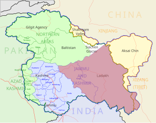
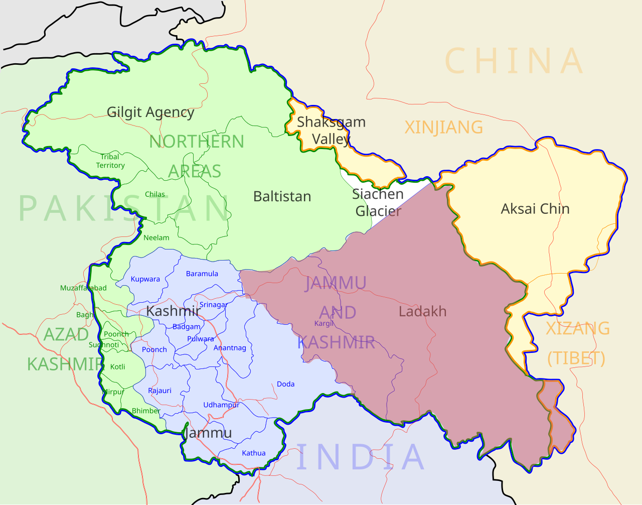
Ladakh locator map |
| Description |
Locator map for the region of w:Ladakh (higlighted in red) in the w:Indian state of w:Jammu and Kashmir |
| তাৰিখ | |
| উৎস |
নিজা কাৰ্য |
| স্ৰষ্টা | |
| অনুমতি (এই ফাইলৰ পুনঃব্যৱহাৰ) |
মই, এই কামৰ স্বত্বাধিকাৰী, ইয়াৰ দ্বাৰা মই এই কামক তলত বৰ্ননা দিয়া অনুজ্ঞাপত্ৰৰ অধীনত প্ৰকাশ কৰিলো: এই ফাইলটো ক্ৰিয়েটিভ কমন্স এট্ৰিবইউচন-চেয়াৰ এলাইক ৩.০ আন্প'ৰ্টেড অনুজ্ঞাপত্ৰৰ অধীনত।
|
| Geotemporal data | |
| Date depicted | second half of 20 century আৰু 21 century |
| Georeferencing | If inappropriate please set warp_status = skip to hide. |
| Archival data | |
| টোকা | Part of WikiProject India Maps |
ফাইলৰ ইতিবৃত্ত
ফাইলৰ আগৰ অৱস্থা চাবলৈ সেই তাৰিখ/সময়ত ক্লিক কৰক।
| তাৰিখ/সময় | ক্ষুদ্ৰ প্ৰতিকৃতি | আকাৰ | সদস্য | মন্তব্য | |
|---|---|---|---|---|---|
| বৰ্তমান | 05:50, 2 December 2012 | | 2,160 × 1,696 (202 KB) | Baomi | 改“XIJANG”为“XIZANG” |
| 00:24, 10 May 2007 |  | 2,160 × 1,696 (260 KB) | Saravask | {{WikiProject_India_Maps |Title=Ladakh locator map |Description=Locator map for the region of w:Ladakh (higlighted in red) in the w:Indian state of [w:Jammu and Kashmir]] |Source= [http://www.koausa.org/Nature/maps.html Map of Kashmir], |Date=May |
ফাইল ব্যৱহাৰ
তলত দিয়া 2 পৃষ্ঠাবোৰে এই ফাইলটো ব্যৱহাৰ কৰে:
ফাইলৰ গোলকীয় ব্যৱহাৰ
তলত দিয়া আন ৱিকিসমূহে এই ফাইলটো ব্যৱহাৰ কৰে:
- awa.wikipedia.org-ৰ ব্যৱহাৰ
- bpy.wikipedia.org-ৰ ব্যৱহাৰ
- ceb.wikipedia.org-ৰ ব্যৱহাৰ
- en.wikipedia.org-ৰ ব্যৱহাৰ
- fa.wikipedia.org-ৰ ব্যৱহাৰ
- he.wikipedia.org-ৰ ব্যৱহাৰ
- hi.wikipedia.org-ৰ ব্যৱহাৰ
- hu.wikipedia.org-ৰ ব্যৱহাৰ
- incubator.wikimedia.org-ৰ ব্যৱহাৰ
- it.wikipedia.org-ৰ ব্যৱহাৰ
- it.wikivoyage.org-ৰ ব্যৱহাৰ
- ja.wikipedia.org-ৰ ব্যৱহাৰ
- ko.wikipedia.org-ৰ ব্যৱহাৰ
- mai.wikipedia.org-ৰ ব্যৱহাৰ
- ml.wikipedia.org-ৰ ব্যৱহাৰ
- nn.wikipedia.org-ৰ ব্যৱহাৰ
- no.wikipedia.org-ৰ ব্যৱহাৰ
- or.wikipedia.org-ৰ ব্যৱহাৰ
- pam.wikipedia.org-ৰ ব্যৱহাৰ
- pnb.wikipedia.org-ৰ ব্যৱহাৰ
এই ফাইলটোৰ অধিক গোলকীয় ব্যৱহাৰ চাওক।