এণ্ডিছ
এণ্ডিজ (Andes) বিশ্বৰ আটাইতকৈ সৰ্বোচ্চ দৈৰ্ঘ্যৰ পৰ্বতমালা। এই পৰ্বতমালা দক্ষিণ আমেৰিকাৰ পশ্চিমে ৭০০০ কিলোমিটাৰ জুৰি বিস্তৃত হৈ আছে। এই পৰ্বতমালাৰ সাগৰ পৃষ্ঠৰ পৰা গড় উচ্চতা প্ৰায় ৪০০০ মিটাৰ। এণ্ডিজ পৰ্বতমালা সাতখন দেশ জুৰি বিস্তৃত হৈ আছে। এইকেইখন হৈছে -ভেনিজুৱেলা, কলম্বিয়া, ইকুৱেডৰ, পেৰু , ব’লিভিয়া, চিলি আৰু আৰ্জেণ্টিনা। .
| এণ্ডিজ (Andes) | |
|---|---|
 Aerial photo of a portion of the Andes between Argentina and Chile | |
| উচ্চতম শিখৰ | |
| শৃংগ | Aconcagua (Las Heras Department, Mendoza, Argentina) |
| উচ্চতা | 6,962 মিটাৰ (22,841 ফুট) |
| স্থানাংক | 32°39′10″S 70°0′40″W / 32.65278°S 70.01111°Wস্থানাংক: 32°39′10″S 70°0′40″W / 32.65278°S 70.01111°W |
| পৰিধি | |
| দৈৰ্ঘ্য | 7,000 km (4,300 মাইল) |
| প্ৰস্থ | 500 km (310 মাইল) |
| নামাকৰণ | |
| স্থানীয় নাম | Quechua: Anti(s/kuna) |
| ভূগোল | |
 | |
| দেশসমূহ | List
|
এণ্ডিজ পৰ্বতমালা প্ৰাকৃতিক ডিপ্ৰেশ্যনৰ দ্বাৰা কেইবাটাও অঞ্চলত বিভক্ত। এণ্ডিজত কেইবাটাও বৃহৎ মালভূমি আছে আৰু ইয়াত অৱস্থিত মুখ্য মহানগৰসমূহ হৈছে- Quito, Bogotá, Arequipa, Medellín, Sucre, Mérida, আৰু La Paz। ইয়াৰ আল্টিপ্লেন’ মালভূমি (Altiplano plateau) তীব্বত মালভূমি (Tibetan plateau) ৰ পিছতে বিশ্বৰ দ্বিতীয় সৰ্বোচ্চ উচ্চতাৰ মালভূমি। এই অঞ্চলসমূহক জলবায়ুৰ ওপৰত ভিত্তি কৰি তিনিটা ভাগত বিভক্ত কৰা হয়- ক্ৰান্তীয় এণ্ডিজ (Tropical Andes ), শুষ্ক এণ্ডিজ (Dry Andes) আৰু সেমেকা এণ্ডিজ (Wet Andes)।
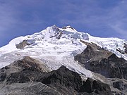
এণ্ডিজ এছিয়াৰ বাহিৰে পৃথিৱীৰ ভিতৰতে সৰ্বোচ্চ পৰ্বতমালা। ইয়াৰ সৰ্বোচ্চ শৃংগটো হৈছে ’Aconcagua’ আৰু ইয়াৰ সাগৰ পৃষ্ঠৰ পৰা উচ্চতা 6,962 মিটাৰ (22,841 ফুট)। ইকুৱেডৰৰ এণ্ডিজত অৱস্থিত Chimborazo শৃংগটো পৃথিৱীৰ কেন্দ্ৰৰ পৰা সৰ্বোচ্চ উচ্চতাত থকা স্থান। এণ্ডিজ পৰ্বতমালাত বিশ্বৰ আটাইতকৈ সক্ৰিয় আগ্নেয়গিৰিসমূহো অৱস্থিত। ইয়াৰ ভিতৰত উল্লেখযোগ্য হৈছে, চিলি-আৰ্জেণ্টিনা সীমান্তৰ Ojos del Salado নামৰ আগ্নেয়গিৰিৰ সাগৰৰ পৰা উচ্চতা ৬,৮৯৩ মিটাৰ (২২,৬১৫ ফুট)।
.jpg)
.jpg)
নামকৰণ
সম্পাদনা কৰকএণ্ডিজৰ নামকৰণ সম্পৰ্কে কেইবাটাও ধাৰণা উপলব্ধ। বহুল প্ৰচাৰিত এক ধাৰণা অনুসৰি এই নাম ’Quechua’ ভাষাৰ শব্দ ’anti’ ৰ পৰা আহিছে যাৰ অৰ্থ ’পূব (east)’।[1]
ভৌগোলিক বিৱৰণ
সম্পাদনা কৰকএণ্ডিজ পৰ্বতমালাক মূলত: তিনিটা ভাগত ভগোৱা হয়-
- দক্ষিণ এণ্ডিজ, চিলি আৰু আৰ্জেণ্টিনা
- কেন্দ্ৰীয় এণ্ডিজ, ইকুৱেডৰ, পেৰু আৰু বলিভিয়া
- উত্তৰ এণ্ডিজ, ভেনিজুৱালা আৰু কলম্বিয়া[2]
এণ্ডিজ ৰেঞ্জত বহুতো সক্ৰিয় আগ্নেয়গিৰি আছে যিবোৰ নিষ্ক্ৰিয় অঞ্চলৰ দ্বাৰা পৃথক চাৰিটা আগ্নেয়গিৰি অঞ্চলত বিস্তৃত হৈ আছে।
আলোকচিত্ৰৰ ভঁৰাল
সম্পাদনা কৰক-
 Chilean huasos, 19th century
 -

-
 Quechua woman and child in the Sacred Valley in Peru
 -

-


তথ্যসূত্ৰ
সম্পাদনা কৰক- ↑ Teofilo Laime Ajacopa, Diccionario Bilingüe Iskay simipi yuyayk'ancha, La Paz, 2007 (Quechua-Spanish dictionary)
- ↑ Miller, Meghan S.; Levander, Alan; Niu, Fenglin; Li, Aibing (2008-06-23). "Upper mantle structure beneath the Caribbean-South American plate boundary from surface wave tomography". Journal of Geophysical Research খণ্ড 114: B01312. doi:10.1029/2007JB005507. Archived from the original on 2010-06-05. https://web.archive.org/web/20100605003245/http://www.gseis.rice.edu/Reprints/047_MillerEL09JGR.pdf। আহৰণ কৰা হৈছে: 2010-11-21.
লগতে চাওক
সম্পাদনা কৰক- Oncken, O. et al. (2006). The Andes. Active Subduction Orogeny. Springer: Berlin. DOI: 10.1007/978-3-540-48684-8
- Biggar, J. (2005). The Andes: A Guide For Climbers. 3rd. edition. Andes: Kirkcudbrightshire. ISBN 0-9536087-2-7
- de Roy, T. (2005). The Andes: As the Condor Flies. Firefly books: Richmond Hill. ISBN 1-55407-070-8
- Fjeldså, J. & N. Krabbe (1990). The Birds of the High Andes. Zoological Museum, University of Copenhagen: Copenhagen. ISBN 87-88757-16-1
- Fjeldså, J. & M. Kessler (1996). Conserving the biological diversity of Polylepis woodlands of the highlands on Peru and Bolivia, a contribution to sustainable natural resource management in the Andes. NORDECO: Copenhagen. ISBN 9788798616801
বাহ্যিক সংযোগ
সম্পাদনা কৰক| ৱিকিমিডিয়া কমন্সত Andes সম্পৰ্কীয় মিডিয়া ফাইল আছে। |
 ৱিকিউৎসত এণ্ডিছ সম্পৰ্কীয় কৰ্ম পঢ়ক।
- University of Arizona: Andes geology Archived 2005-09-22 at the Wayback Machine
- Blueplanetbiomes.org: Climate and animal life of the Andes Archived 2007-12-14 at the Wayback Machine
- Discover-peru.org: Regions and Microclimates in the Andes
- Peaklist.org: Complete list of mountains in South America with an elevation at/above 1,500 মিটাৰ (4,920 ফুট)